|
||||||||||
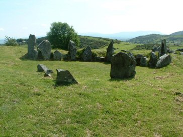
Newry nestles in a valley of the Clanrye river, at the head of Carlingford Lough and between the Mourne and Cooley Mountains. It also lies on the border between counties Down, Armagh and Louth. It is the market town for much of South Down and South Armagh. The Mourne and Cooley Mountains were formed as igneous batholiths and subsequent erosion revealed the granitic summits we see today. During the last ice age (30,000-10,000 years ago) temperatures plummeted and the northern ice-cap extended equatorially. Glaciers and ice streams covered most of Ireland and shaped a beautifully rolling landscape. Glacial drumlins and eskers extend over much of Ireland and many can be seen around Newry. Glacial sand and gravel deposits also form the substrate for beaches such as Cranfield and Kilkeel. The first settlers, we believe of 10,000 years ago, were neolithic and mesolithic hunter-gatherers. However on the introduction of agricultural techniques from the Middle East much of Ireland's natural climax vegetation - oak woods - was felled to make way for fields. 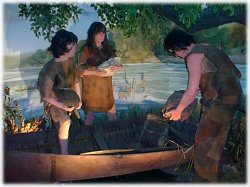 Some small patches of this oak wood still exist to this day, for example, at Kilbroney Park, Rostrevor. This modification of the land led to the present day patchwork of cultivated green fields and hedgerows. Some small patches of this oak wood still exist to this day, for example, at Kilbroney Park, Rostrevor. This modification of the land led to the present day patchwork of cultivated green fields and hedgerows.The geological structure of Down and Armagh consists mainly of shales and greywackes of Silurian age, formed in an ancient ocean more than 400 million years ago. They are an extension of the Southern Uplands of Scotland. Into these silurian rocks the tertiary igneous batholiths were intruded 390 million years ago. These batholiths later solidified to form the granites of the Mourne and Cooley Mountains. In the tertiary period (65 million years ago) the area was a centre of volcanic activity. Where the silurian rocks met the Newry granite a circular fracture developed and into this a series of acidic lavas was intruded. These solidified to form the ring-dykes. The ring of Gullion in South Armagh is a fine example of a ring-dyke intrusion and attracts geologists from all over the world. The drumlin fields around Newry are streamlined 'whaleback' hills, whose shape was controlled by ice flow at the base of the thick ice sheet. One major centre of ice was the Lough Neagh basin which pushed streams of ice into Carlingford Lough, Dundalk Bay and Dundrum Bay. It was at the base of these ice streams that the mysterious conditions existed for drumlin formation. At the edges of these drumlin fields are moraines, large banks of glacial material pushed forward by the ice at it's margins. Moraines can be seen on the coast to the east of the Mournes (near Cranfield) and to the south of Carlingford Mountain. The tourist taking the Newry Bypass route is presented with a pleasing panorama of the "basket of eggs" topology typical of drumlin country.
|
||||||||||
|
||||||||||
 Small fragments of the once extensive lowland bogs remain in the Ring of Gullion. These bogs formed an important part of rural life in the past and were the centre of much turf-cutting, land
reclamation and poteen distilling. Soils in more lowland areas consist of brown earths and some podsols formed from the boulder clay deposited during the last ice-age, and subsequently altered by natural vegetation and human interaction. On the valley sides and hillslopes of South Armagh there are still semi-natural woodlands of Hazel and Ash with some Sycamore, Oak, Rowan and Willow. The most notable of these are at Killeavy Castle, Hawthorn Hill and Forkhill.
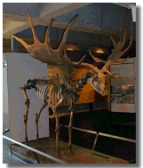
While Ireland may once have been rich in native wildlife the domination
of the landscape by man has gradually eradicated suitable habitats.
Nevertheless, widespread schemes now operate to expand on pockets of
native vegetation and wildlife habitats. Many species have been
reintroduced including otters, red squirrel, voles and deer.
Small fragments of the once extensive lowland bogs remain in the Ring of Gullion. These bogs formed an important part of rural life in the past and were the centre of much turf-cutting, land
reclamation and poteen distilling. Soils in more lowland areas consist of brown earths and some podsols formed from the boulder clay deposited during the last ice-age, and subsequently altered by natural vegetation and human interaction. On the valley sides and hillslopes of South Armagh there are still semi-natural woodlands of Hazel and Ash with some Sycamore, Oak, Rowan and Willow. The most notable of these are at Killeavy Castle, Hawthorn Hill and Forkhill.
While Ireland may once have been rich in native wildlife the domination
of the landscape by man has gradually eradicated suitable habitats.
Nevertheless, widespread schemes now operate to expand on pockets of
native vegetation and wildlife habitats. Many species have been
reintroduced including otters, red squirrel, voles and deer.